
The Best Hikes in San Francisco and Beyond
Lace up your boots and prepare to see the most breathtaking corners of San Francisco and the Bay Area on these incredible hikes.
San Francisco's year-round temperate climate and forty-plus hills make the city a hiker's paradise. The greater Bay Area is no different, brimming with natural wonders like towering redwoods, rugged cliffs, and lush valleys, all within a short drive of the city. Every trail, from Mt. Diablo to Muir Woods, has photo-worthy scenery. Here are our picks for the best hikes in San Francisco and beyond.
San Francisco City Hikes
If you're ready to go beyond regular walking tours and actually hike through San Francisco, we've got options for you.
Twin Peaks
You can start right in the center of the city with Twin Peaks. Climbing the easy half-mile trail increases your elevation by 400 feet, putting you a total of 925 feet above sea level. This is the place to check out the best 360-degree view inside city limits. Twin Peaks is easily accessible by public transportation. If you take Muni Metro K, L, or M trains to the Castro Station, the trailhead is about one mile away. Or, take Muni bus 33 or 37 from Castro Station to access the trailhead.
Mount Davidson
Another option is the 1.5-mile Mount Davidson Trail loop, which takes you to the highest point in the city. Mount Davidson is home to a San Francisco landmark, the historic Mount Davidson Cross. This icon stands 103 feet tall, so it can be seen from most points in the city. It is here that the Annual Easter Sunrise Service has been held since 1923. The simplest way to get to Mount Davidson is by public transportation. Take BART from downtown to the Glen Park station, then the 36 Muni bus to the corner of Dalewood Way and Myra Way. Or, take the 36, 43, 44, 48 or 52 Muni bus to arrive at the Mount Davidson hiking path entrance on the northwest side of the peak.

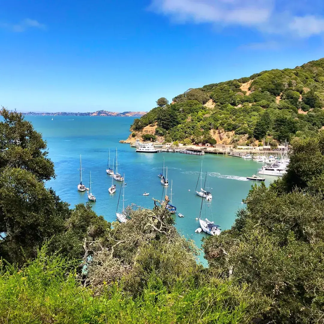
Angel Island
If you want to take a hike that circles an entire island without ever leaving city limits, take the Angel Island - Tiburon Ferry or the Golden Gate Ferry from San Francisco to Angel Island State Park. See the San Francisco skyline from a brand-new vantage point as you trek the five-mile loop.
Golden Gate National Recreation Area – Lands End
Hikers come from around the country to enjoy the Golden Gate National Recreational Area (GGNRA). More than 250 hiking trails crisscross the GGNRA, and all of them are worth a visit. Within this expansive park, which spans both the Marin and San Francisco sides of the Golden Gate, there are trails that cater to every interest and ability. However, if you only have time for one, choose the Coastal Trail for an opportunity to hike along the westernmost edge of the city—and the continent.
This route takes you through a cypress forest and along the 200-foot-high cliffs that guard the entrance to San Francisco Bay. Countless vessels have crashed trying to navigate the narrow channel, and you can see some of the wreckage from lookout points along the trail.
The Coastal Trail connects to the Sutro Baths Upper Trail and the Sutro Ruins Trail. Park in the lot on Point Lobos Avenue to access both the ruins and the trail, which is approximately 1.5 miles long. This hike is generally quite easy, but there are some stairs to climb. You can avoid the steepest sets of stairs, but keep in mind that you will miss out on the best views.
One of the most popular is the Lands End Trail, which is ideal for hikers of moderate ability. On the northwest tip of San Francisco, this four-mile path takes you to spectacular views of the Golden Gate Bridge. If you prefer a hike on more stable ground, the Golden Gate Promenade is partially paved. You can walk from Fort Point to Aquatic Park along the 3.5-mile path, stopping frequently for photos on the waterfront.
Before or after your hike, leave time for one more adventure. Near the parking area next to the Lands End Lookout Visitor Center, the ruins of the massive Sutro Baths offer a glimpse into a forgotten era, when San Francisco residents spent their leisure time at the world’s largest indoor swimming facility. At its peak, the Sutro Baths covered three acres and had seven pools of varying temperatures that could accommodate up to 10,000 people.
Pro tip: Take the 38 or 38R bus to reach the Lands End Lookout Visitor Center from downtown and Union Square.
Presidio Hiking Trails
You can enjoy 24 miles of hiking trails on the Presidio grounds. Try the three-mile trail that takes you past four of Andy Goldsworthy’s acclaimed sculptural installations: "Spire," "Wood Line," "Earth Wall," and "Tree Fall." The Presidio’s location on the Pacific Flyway, a heavily-trafficked migratory route for birds, makes hiking in the park especially exciting for birdwatchers.
Pro tip: Take the free Presidio Go Shuttle from downtown San Francisco to the park.

North Bay Hikes (Marin County)
Golden Gate National Recreation Area - North of the Golden Gate Bridge
Hikers looking for bigger challenges may wish to explore other sections of the GGNRA. Try the 1.2-mile Ocean View Trail through the Muir Woods National Monument. The path wanders among old-growth redwoods, then takes you up where you can see the 600 to 800-year-old trees from above. For a route that loops, turn onto Lost Trail, then follow Fern Creek Trail, which takes you back to the start.
Hikers traveling with younger family members or those looking for a less strenuous hike will enjoy the Tennessee Valley Trail. This 1.7-mile path (3.4 miles round-trip) stretches from the parking area to Tennessee Beach. If you time your arrival just right, you may catch a glimpse of the shipwrecked SS Tennessee, revealed by the outgoing tides.
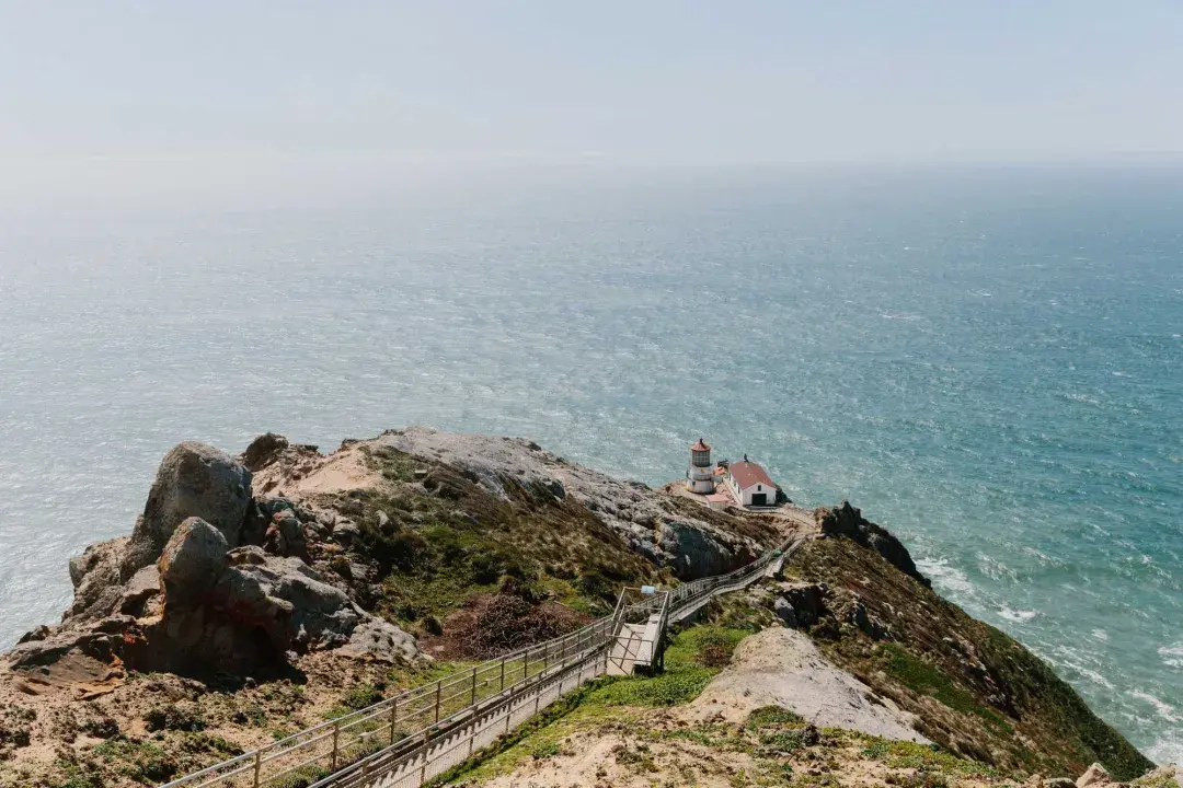
If you are prepared for rough terrain, follow the half-mile trail that ends at Point Bonita Lighthouse. If you plan to go inside the lighthouse, which is still active, be advised that hours are quite limited. Check the website for open hours and information.
Point Reyes National Seashore - Alamere Falls
It takes dedication to complete a 13-mile round-trip trek, but this one is well worth the effort. When you reach Wildcat Beach, a dramatic waterfall awaits. Alamere Falls is a tidefall, which is relatively uncommon. Fed by Alamere Creek, the falls pour over a 30-foot cliff onto the beach below. During high tide, it’s hard to tell where the falls end and the surf begins.
Be aware that this hike isn’t for the faint of heart. Aside from the distance, you gain 1,442 feet of elevation, making it somewhat strenuous. There is real danger near the edge of the cliff, both up top and down below. Stay away from the edge to avoid risking a fall. On the beach, keep in mind that rocks can tumble down at any time.
There are three trailheads where you can park and launch your expedition: Bear Valley (6.3 miles via the Bear Valley, Glen, and Stewart Trails), Palomarin (5.5 miles via the Coast Trail), and Five Brooks (7.1 miles via the Stewart Trail).
Be advised: Alamere Falls may be limiting visitor capacity to better preserve the local environment.
Kirby Cove
Not all trails take you up hills and mountains. In the case of Kirby Cove, your hike starts with a steep descent. You'll pass by eucalyptus, pine, and cypress trees. When you reach the end, you will find yourself on a cozy beach. Take in panoramic views of the San Francisco Bay and the Golden Gate Bridge while gentle waves lap at your toes. To get there, park on Conzelman Road and head down old Kirby Cove Road.
Kirby Cove became popular with adventurers in search of a secret rope swing that was once located in the area. Unfortunately, the swing has been removed, but that doesn’t make Kirby Cove any less spectacular.
South Bay and Daly City Hikes
Mission Peak
Mission Peak is popular for its 360-degree panoramic views of the Bay Area, but that’s not the only reason hikers make the climb. When you reach the 2,517-foot summit, an unusual sight awaits in the form of a six-foot steel pole with sighting tubes that point to a variety of distant landmarks.
A selfie with the “Mission Peeker” is a badge of honor. The sculptor who designed the monument intended it as a statement about environmental issues. Sealed inside, there is a bottle of wine from 1990, along with five time capsules. Each contains artifacts that represent the most pressing issues of the decade. The time capsules are scheduled to be opened in 2090, one hundred years after they were created.
The hike is six miles round trip and it is fairly steep. You have three trails to choose from. The Hidden Valley Trail and the Peak Meadow Trail take you up the western face of the mountain, while the Mission Peak Trail climbs the northern face. Mission Peak is about an hour outside of San Francisco in the city of Fremont.
Pacifica
On the Peninsula, experienced hikers can trek from the ocean to Montara Mountain’s peak, which goes from sea level to 2,000 feet in approximately one mile! Start at Montara State Beach or Gray Whale Cove State Beach parking lot.
If you prefer a more moderate hike, start at the Gray Whale Cove parking lot, then follow the Gray Whale Cove Trail at an elevation of less than 200 feet for dramatic ocean views and even a peek at the sandy stretch of Montara State Beach.
Mussel Rock Park Nature Preserve
Long walks on the beach might be cliché, but there is nothing cliché about Mussel Rock Park. The endless expanse of ocean on one side and rugged cliffs on the other are just the beginning. Park on the bluff and follow a trail down to the water, where you can check out tide pools before beginning your trek. This hike can be as long or as short as you wish. To the north, there is walkable beach for the entire nine miles it takes to reach the former Cliff House. To the south, there is a man-made rock arch where the trail ends.
The most adventurous hikers like Mussel Rock Park for an unusual amenity. It is home to several spectacular paragliding launch points where you can soar above the coast. Even if you prefer to stay on the ground, watching others fly is exciting.
The parking lot is located at the end of Westline Drive in Daly City. Make it a point to stay through sunset; the colors are particularly brilliant from a Mussel Rock vantage point.
More Amazing Hikes Beyond the Bay
In the East Bay, you'll find Mount Diablo State Park, which is named for the 3,849-foot peak that offers breathtaking views of the surrounding hills and valleys. There are hiking trails appropriate for every level of ability, but the truly spectacular views are only available to those willing to take on a challenge.
One of the most popular options is the Donner Creek Loop Trail, a five-mile trek that passes by Donner Creek Falls. For a longer hike, try the Mount Diablo Grand Loop Trail, which includes approximately seven miles of inclines and declines. The most experienced hikers prefer the 13-mile loop from Mitchell Creek to Diablo Summit. This one takes you all the way to the top, a total elevation gain of 3,585 feet.
North of San Francisco in Marin County, Mount Tamalpais State Park offers a network of trails ranging from easy to moderate levels of difficulty. Some trails are just over two miles long, while others span a full 16 miles. Visitors hike, bike, jog, and picnic throughout the park year round, making it one of the area’s most popular attractions.
If you have the time and you are up for a challenge, you can climb to the mountain’s 2,571-foot peak. From the top, you can see the Farallon Islands, which are 25 miles out to sea. When conditions are just right, some hikers have glimpsed the snowy Sierra Nevada mountains, which are more than 150 miles away.
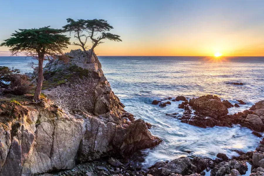
Drive the Iconic Highway 1
California's Highway 1 has fully reopened! Now's your chance to take an epic road trip down the gorgeous California coast. If breathtaking nature is what you crave, there's no route more scenic than this one. From the Lone Cypress at Pebble Beach to the iconic Bixby Bridge at Big Sur, Highway 1 will take you to some absolutely stunning locations.

Carol is a digital marketer creating media-rich content for global audiences covering travel, San Francisco and the Bay Area, food & drink, outdoor experiences, and cross-cultural storytelling. Her work is found in the San Mateo Daily Journal and The Skyline View (Skyline College). Before travel writing, her professional background included working internationally in business, nonprofits, and government. She lives in San Francisco with her family and regularly explores the parks in her city, especially untamed McLaren Park.
You May Also Like

Dive into San Francisco's maritime heritage aboard a World War II-era submarine
Across the Bay Bridge lies a community known for its creativity, activism, and cuisine. It's Berkeley, and here's how you can spend a terrific weekend there.

Immerse yourself in these brilliant works by some of the world’s most notable light artists at these San Francisco museums.

San Francisco is a perfect city to visit with your dog. @hellorubydoodle shows how four-legged companions can enjoy San Francisco just as much as you do.

Visit sights seen in the long-awaited follow-up to the blockbuster trilogy of action films, The Matrix, in San Francisco.

One of the buzziest neighborhoods in San Francisco is full of fantastic and fashionable boutiques where you'll find items not available anywhere else.

Find tranquility amid the landscaped lawns, serene waterfalls, and vibrant gardens at the cultural heart of San Francisco.

Explore these San Francisco dispensaries bringing a new emphasis on style to the cannabis experience.

Get the fast facts on San Francisco's largest, greenest, and newly renovated convention venue, The Moscone Center

Sign Up for Our Newsletter
Be the first to know about upcoming events and festivals, new restaurants, special deals, and everything else happening in the City by the Bay.